Making sense of the Irish Civil War can be challenging; a fast‑moving conflict, shifting allegiances, local events, and a form of warfare that doesn’t fit neatly into a traditional military narrative. For students, this can make the topic feel confusing and hard to visualise—particularly when trying to understand where events happened and why location mattered.
The Irish Civil War timeline was developed with these challenges in mind. It is a chronological, location‑based digital narrative that maps key events of the civil war across Ireland.
The Irish Civil War in the A-level curriculum
The timeline grew out of my doctoral research into the use of digitised historical artefacts in the A‑level history classroom. One finding was that, compared to topics such as the Easter Rising, there were relatively few teaching resources focused on the Irish Civil War*—particularly resources that helped students grasp the complexities of the unconventional conflict. Teachers involved in the research described how they routinely used visual primary sources to engage students and support understanding. However, many also noted how difficult it could be to convey the realities of guerrilla warfare:
“Some of the students have a bit of mental block when it comes to aspects of military history … of the Anglo-Irish war or the Civil war, so I try to break it down as much as possible … look at the wider context and … bring in as many pieces of visual evidence … to give them some sort of hook or some sort of reference point really.”
Students echoed these difficulties, particularly in relation to understanding shifting allegiances and the highly localised nature of the conflict:
“ … for civil war, I really struggled over who is on what side half the time … and just thinking what is going on!”
Others emphasised the importance of visualising landscape and terrain in order to understand tactics:
“… a picture of the terrain, to show how the flying columns used to interact in Kerry, they used the natural landscape and I didn’t understand that it was because it was so rocky … they can hide, I just imagined a field, … “
These findings underscored the need for a resource that integrated chronology, geography, visual evidence, and interpretive narrative.
Irish Civil War timeline: geography and chronology combined
The Irish Civil War timeline combines interactive maps, narrative text, digitised artefacts, and curated secondary sources to create a location-based historical narrative. It foregrounds the role of landscape and place in shaping the conflict and enables learners to explore events progressively in both time and space.
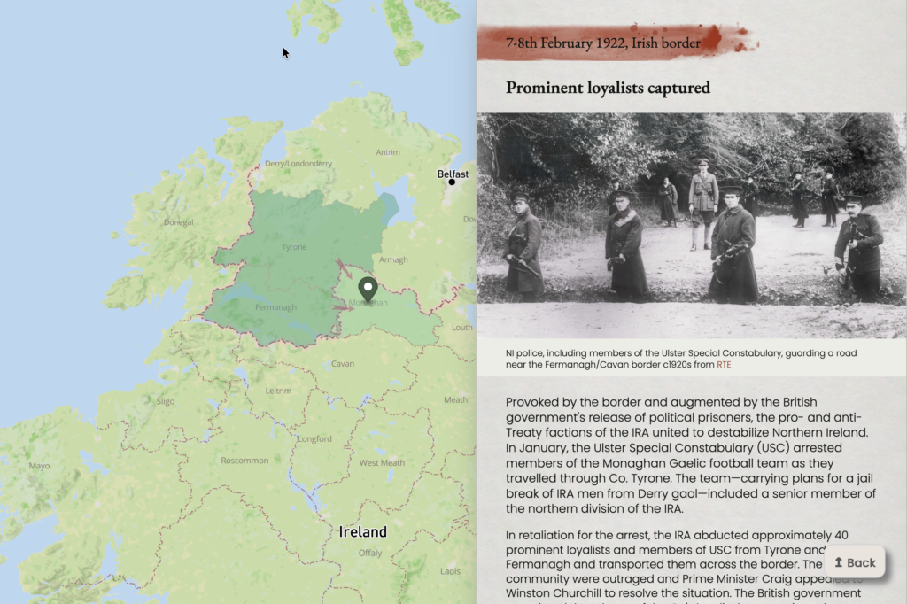
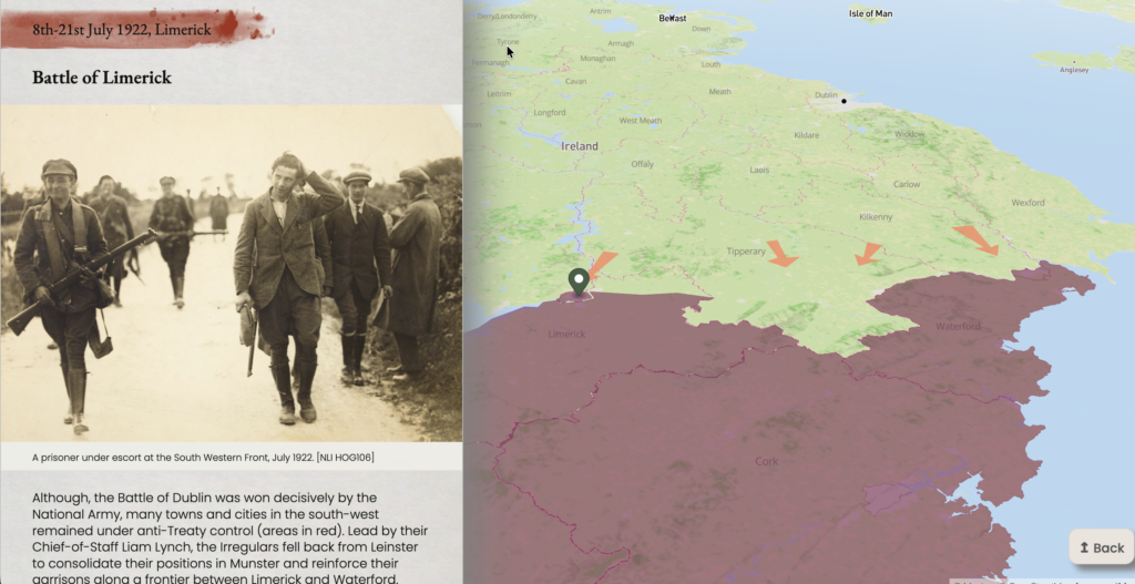
Each entry represents a significant event in the conflict and contains a synopsis, a digitised historical artefact and a link to a secondary article for extended reading. Events are contextualised using custom map layers to address the spatial challenges highlighted by students. Colour-coded counties demonstrate pro- and anti- Treaty allegiances and territorial control whereas freehand annotations are used to show troop movements, and strategic actions, such as the National Army advance into Munster and the seaborne landings during the Battle of Cork. This combination of elements enable students to engage with events at multiple levels, supporting quick reference, visual interpretation, geographical awareness, and deeper historical understanding.
In the classroom
The timeline is designed to be flexible in how it can be used in the classroom. It can displayed on a whiteboard to be used as a whole‑class teaching aid to introduce the topic or to support source analysis, alternatively, it can used by students for independent or group research or as a revision tool. As the content is aligned with CCEA curriculum guidance, use of the timeline can be integrated directly into existing schemes of work.
The aim of the Irish Civil War timeline is to support students in developing a more nuanced understanding of a complex, fragmented, and fast-moving conflict, while offering teachers a visually rich, research-informed tool aligned with curriculum requirements.
Thank you to the HTANI team for their support in making this resource.
*Since completing my PhD, RTE and UCC have released the Irish Civil War Fatalities project which explores the conflict through the location and chronology of fatalities. This source was invaluable in my research; its articles informed many of the maps and it is referenced extensively for additional reading.
Further Information
- The custom map layers and timeline functionality were built using HTML + CSS + JS + the Mapbox toolkit see Scrolling-telling map for a tutorial.
- Decade of Centenaries timeline provides an illustrated introduction to the Partition period of Irish history
- The Partition Portal provides a Partition era-resources mapped to the A-level history curriculum
- RTE and UCC Irish Civil War Fatalities collection for in-depth exploration of the conflict.
- Síobhra Aiken’s article The silence and the silence-breakers of the Irish Civil War explores contemporary attitudes to coverage of the war.